

Ward Map 2025
Kanjirappally Grama Panchayat
Official Ward Map - 2025
Official GIS Ward Map from the Panchayat's KSMART Portal
KSMART Ward Details
Updated ward boundaries and information available through the KSMART system.
Interactive Navigation
Features such as zoom map, inspect areas, and search locations.
GIS Technology
Prepared using the official GIS technology of the Local Self Government Department.
Kanjirappally Grama Panchayat Ward Map Image
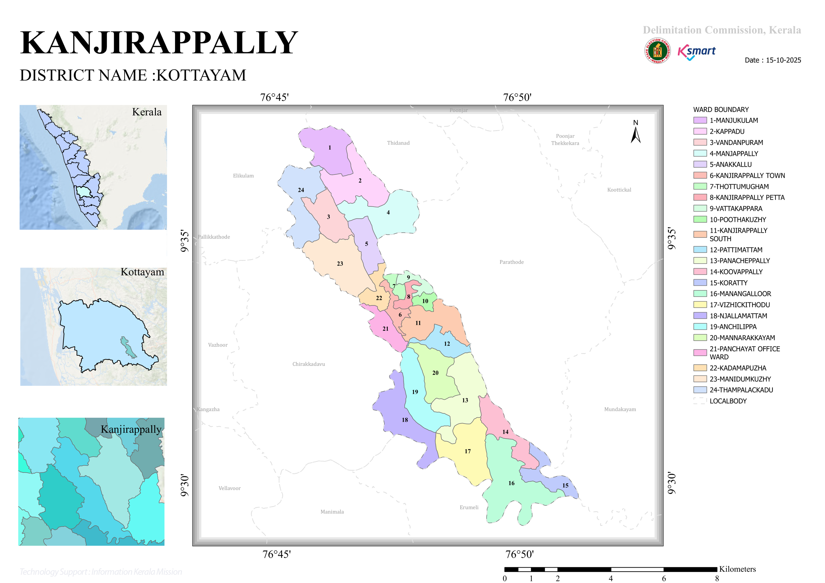
Download the official image and order of the Panchayat's new ward delimitation below.
- Location: Kanjirappally Grama Panchayat is situated in the eastern hilly region of Kottayam district.
- Wards: As per the 2025 delimitation, the panchayat is divided into a total of 24 wards.
- Boundaries: North: Thidanad, Elikulam, and Pallikkathode areas; East: Parathode, Mundakayam, and Erumely Panchayats; West: Chirakkadavu, Manimala, and Kangazha areas; South: Erumely area.
All Wards in Kanjirappally Grama Panchayat:
- Ward Population: The population in each ward ranges strictly between approximately 1,680 and 1,920, maintaining an excellent demographic balance across wards.
- Most Populous Wards: Vattakkappara (1,922), Pattimattam (1,922), Anakkallu (1,907), Manjakkulam (1,904).
- Least Populous Wards: Kanjirappally Town (1,687), Mannarakkayam (1,693), Koratti (1,699), Vizhikkithodu (1,699).
- Manimala River: Flows through the eastern and south-eastern regions of the panchayat, serving as a natural boundary for Koratti, Manangalloor, Vizhikkithodu, and Njallamattam areas.
- Tributaries: Numerous small streams and canals serve as natural ward boundaries.
- Transportation: NH 183 (passing via Town, Petta, Poothakkuzhi, Kanjirappally South) along with major road corridors make the panchayat a vital transport hub.
- Urban Core: Kanjirappally Town, Petta, Panchayat Office Ward.
- Suburban Areas: Poothakkuzhi, Kanjirappally South, Anakkallu, Thottumugham.
- Rural/Agricultural Belts: Koratti, Manangalloor, Vizhikkithodu, Njallamattam, Mannarakkayam, Panacheppally.
- Strengths & Challenges: Major strengths include the presence of NH 183, rich water resources, and proximity to the Sabarimala pilgrimage route, while key challenges involve hillside road infrastructure and riverbank conservation.
Kanjirappally Grama Panchayat is a water-rich, strategically connected hilly local body blending both urban and rural features. A balanced distribution of population across its 24 wards, a robust road network, and abundant natural water sources provide an excellent foundation for its sustainable development.


